Suddenly we find ourselves stuck. COVID-19 has closed off much of the entertainment we’re used to having access to and, in some cases, we are being told to not even leave our homes. You know what? It is for the best! Stopping a pandemic should be the most important task for the planet. Yet, it is hard to feel so detached for the rest of the world.
I compiled a few of my favorite sources for real-time (or close to it) information about our planet. We might be staying in one place, but the world keeps moving.
Earthquakes
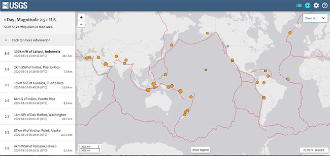
Map of global earthquakes over M2.5 on March 16, 2020. (Credit: USGS)
On the average day, there are dozens and dozens of earthquakes that can be detected by the world’s global seismic network. The USGS Earthquake page keeps you up to date on all the shaking. If you click the menu in the top right, you can check the scope of the map and the lower limit for the size of the earthquakes.
Volcanoes
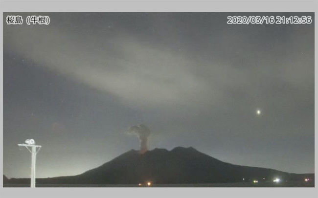
Webcam image of Sakurajima in Japan on March 16, 2020. (Credit: JMA.)
So many volcanoes these days have webcams pointed toward them! You can watch the currently active volcanoes for new blasts or lava flows. Or, you can just watch the volcanic vistas. My favorites include:
Alaska Volcano Observatory: The multitude of volcanoes in Alaska are covered with webcams. Currently, four volcanoes are on heightened alert: Great Sitkin, Cleveland, Semisopochnoi and Shishaldin — and all of these have webcams save for Semisopochnoi. You can even track the shaking at many volcanoes through their webicorders. Note: Some may not be working currently because we're moving out of the harsh Alaskan winter.
Japanese Meteorological Agency: One of the most complete sets of volcano webcams out there ... the only problem is the page is only in Japanese! This makes it a little tricky to pick a specific volcano if you don’t read the language. The menu on the right lets you see the volcanoes of a specific region (Hokkaido, Tohoku, Kanto and Chubu, Izu/Ogasawara Islands and Kyushu from top to bottom).
Just pick one and see what you see — although here are some of the most active or picturesque Japanese volcanoes: Asama — 浅間山 鬼押 in Kanto/Chubu; Fuji — 富士山 萩原 in Kanto/Chubu; Aso — 阿蘇山 車帰 in Kyushu; Suwanosejima — 諏訪之瀬島 寄木 in Kyushu and Sakurajima — 桜島 牛根 in Kyushu.
Kamchatka and Kurile Islands: Russia has a robust collection of webcams looking at some of the most active volcanoes on Earth. These include Klyuchevskoi, Shiveluch, Bezymianny and many more.
Yellowstone: You can watch the geothermal features of North America’s famed caldera, including the geysers like Old Faithful. Yellowstone National Park even gives you estimates of the next spouting at Old Faithful so you can come back to see the action.
Satellites
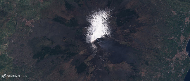
Etna in Italy seen by Sentinel-2 on March 14, 2020. (Credit: ESA.)
One of the most amazing aspects of our modern world is all the satellite imagery that allows you to see what is happening almost anywhere in near real time.
NASA Worldview: This is about as real-time satellite images as you get. The NASA Worldview map allows you to see the Terra and Aqua MODIS as well as the Suomi NPP VIIRS images almost as they arrive. You can toggle different datasets on the menu to the left and take “snapshots” with the menu in the top right.
Zoom Earth. Zoom integrates data from many freely accessible satellite images into one easily searchable site. You can zoom in to see almost anywhere on the planet and scroll back through the archives to find specific events. Zoom combines weather satellite data from Himawari-8 with Earth-observing satellites like Suomi-NPP.
Sentinel Hub Playground: ESA allows you to search the near real-time images from the Sentinel satellites. You can search for the location in the top right and select data from the left-hand menu. Find something you like? Click “generate” in the bottom of the left side to create a downloadable image.
NASA Earth Observatory: Finally, a curated set of satellite images can be found at the incredible NASA Earth Observatory. These include everything from volcanoes to storms to cities to glaciers, tapping the resources of the Terra, Aqua and Suomi satellites as well as the USGS/NASA Landsat system.
Hopefully these resources will help you keep tabs on the world over the next few weeks. The planet is amazing and resilient and so are we. Enjoy what you can discover!
https://www.discovermagazine.com/planet-earth/watching-the-planet-while-stuck-in-the-house
2020-03-16 13:06:26Z
CBMiWmh0dHBzOi8vd3d3LmRpc2NvdmVybWFnYXppbmUuY29tL3BsYW5ldC1lYXJ0aC93YXRjaGluZy10aGUtcGxhbmV0LXdoaWxlLXN0dWNrLWluLXRoZS1ob3VzZdIBAA
Bagikan Berita Ini


0 Response to "Watching the Planet While Stuck in the House - Discover Magazine"
Post a Comment